Yellow storm warning issued as UK heatwave set to continue

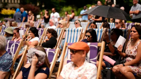 PA
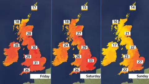
PAA heatwave across the UK is to intensify on Saturday, bringing temperatures of up to 34C and a yellow warning for thunderstorms.
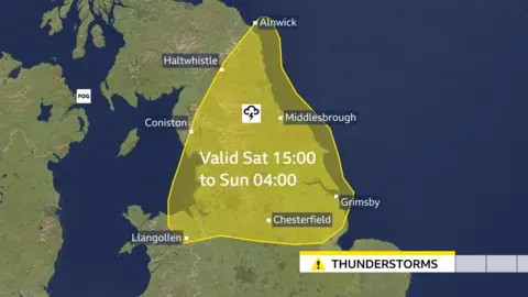
The Met Office issued the storm warning for parts of northern England, the Midlands and Wales from Saturday afternoon into Sunday, with the heat and humidity expected to fuel torrential downpours.
Ahead of the storms, temperatures soared to more than 30C across parts of the UK on Friday, with Scotland, Wales and Northern Ireland all recording their warmest days of the year so far.
An amber heat-health alert in England issued by the UK Health Security Agency (UKHSA) will remain in force until Monday.
The yellow weather warning for storms will remain in place from 15:00 BST on Saturday until 04:00 on Sunday, with the potential for localised flash flooding, large hail and lightning.
With the amber heat-health alert in place, the UKHSA warns of likely significant pressures across health and social care services.
This could include a rise in deaths, particularly among those aged 65 and over or people with health conditions.
By Friday afternoon, many regions were expected to meet the criteria for a heatwave - which means a temperature threshold is sustained for three consecutive days - according to the Met Office.
The threshold varies across different regions, from 25C in northern and western parts of the UK to 28C in south-eastern England.
A heatwave was declared in London on Friday, where it passed the 28C threshold for three days in a row.
On Thursday, Suffolk became the first area in the UK to officially enter a heatwave, after temperatures surpassed 27C for a third consecutive day.
The hot weather pushed north on Friday with temperatures close to 30C in Albemarle, Northumberland and Newcastle. It's the hottest weather recorded in these areas since July 2022.
Wales saw a high of 30.8C in Whitechurch, Pembrokeshire, while Castlederg in Norther Ireland got to 29.5C, and 28.9C was recorded in Drumnadrochit, in the Scottish Highlands.
England recorded its highest temperature on Thursday of 32.2C. Heathrow reached a high of 29.5C on Friday.
Humidity has been increasing through Friday into Saturday, making the heat feel more uncomfortable, particularly at night.
On Friday night, the temperatures may fall no lower than 17C or 18C in many parts of the country.
Some areas are also at risk of a "tropical night" - where overnight temperatures do not drop below 20C - over the next two days.
Minimum temperatures tend to be at the end of the night – not when people are going to bed to try to sleep.
At 23:00 on Friday temperatures will still be around 24C for large parts of England and Wales.
On Saturday night, as cooler and fresher air pushes in from the west, the highest temperatures overnight will be restricted to eastern England, where again they may fall no lower than 18C.
While heatwave conditions are likely to continue, some relief is anticipated on Sunday, when the south and east of England will dip to the high 20s. Elsewhere, cooler air will gradually sweep in from the west.
Temperatures will drop further into Monday - but could rise towards the heatwave threshold again in the latter half of next week.
Despite the current heat being record-breaking for 2025, temperatures are still below the June peak of 35.6C in 1976.
A developing area of high pressure is helping to draw hot weather in from other parts of Western Europe. France and Spain could see temperatures close to 40C over the coming days.
Firefighters have responded to more than 500 wildfires across England and Wales this year - a 717% surge on the same period in 2024, the National Fire Chiefs Council said.
NFCC Chairman Phil Garrigan said the organisation was "deeply concerned about the escalating threat of wildfires this summer", which he warned have "the potential to become more frequent, intense and dangerous".
The organisation is urging the public to be careful when lighting barbecues and handling objects, such as glass bottles, that can cause a fire outside.
While linking climate change with specific individual extreme weather events can be difficult, scientists say that climate change is generally making heatwaves hotter and longer.
The World Weather Attribution group says that the chance of reaching 32C in June has increased by 100 times since the pre-industrial era.
Meanwhile, the chance of a three-day June heatwave had increased tenfold due to human-induced climate change, going from a one-in-50-year event to a one-in-five-year event.
Ben Clarke, a researcher at the Centre for Environmental Policy at Imperial College London, said that with "every fraction of a degree of warming, the UK will experience hotter, more dangerous heatwaves".
He added: "This means more heat deaths, more pressure on the NHS, more transport disruptions, tougher work conditions and poorer air quality."
Dr Agostinho Sousa, head of extreme events and health protection at UKHSA described heat as the "silent killer".
"It will impact all of us, even people who consider themselves healthy," he told BBC Breakfast.
He advised people to look out for vulnerable individuals on public transport and to keep an eye on elderly people.

Get our flagship newsletter with all the headlines you need to start the day. Sign up here.